Project Objective
- To carry out pre- and post-earthquake analysis; utilising satellite imagery via a difference detection method, whilst also conducting manual pre-damage assessments using photographs taken from the ground (from a vehicle),
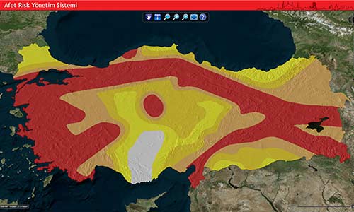
- Incorporating earthquake hazard maps produced for the Istanbul region using probabilistic methods, along with the results of loss estimation analyses linked to these maps,
- As part of integration efforts, incorporating data on DASK policies (including location) alongside real-time earthquake hazard maps (BOUN-KRDAE) and the results of loss estimation analyses,
- Capable of performing financial loss estimates by correlating the obtained earthquake hazard, loss estimation and policy location data with one another using the methodology to be developed, and analysing information received from various channels,
- The aim is to establish a map- and web-based system capable of performing spatial analyses by correlating this information obtained from various sources with one another.
Project Name
Disaster and Risk Management System (ARYS)
Project Period
2015
Project Area
Istanbul
Project Partners
DASK, GRM Bilişim